AEVEX Blog
Remote Sensing Technology for Advancing Wildfire Management: UAVs for Cost-Effective, Resource-Saving Systems
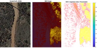
Leveraging Advanced Remote Sensing Technologies to Protect our Communities and Natural Resources Wildfires consume millions of acres of land every year, destroying homes, communities, and infrastructure across the United States and around the globe. Fire seasons are...
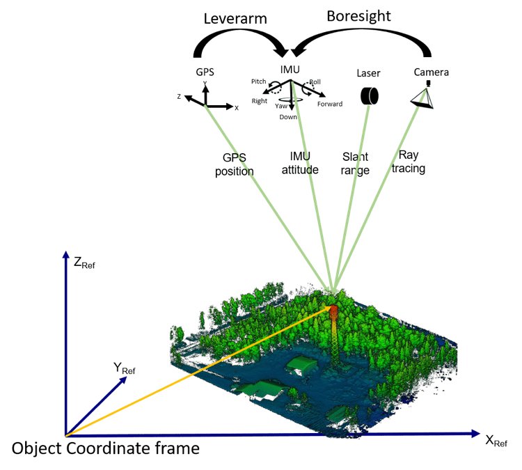
LiDAR Boresight Calibration and Strip Alignment – Part 2
Understanding the Role and Impact of Each on your UAV-LiDAR Missions This blog (second in a two-part series) continues our explanation of the variables which influence boresight calibration and strip alignment when flying drone-based LiDAR missions. If you missed the...
LiDAR Boresight Calibration and Strip Alignment – Part 1
Understanding Two Critical Principles of LiDAR Data Acquisition If you are familiar with any type of LiDAR data acquisition, you have likely stumbled across terms including ‘boresight calibration’ and ‘strip alignment’ (or strip adjustment). These terms relate to...
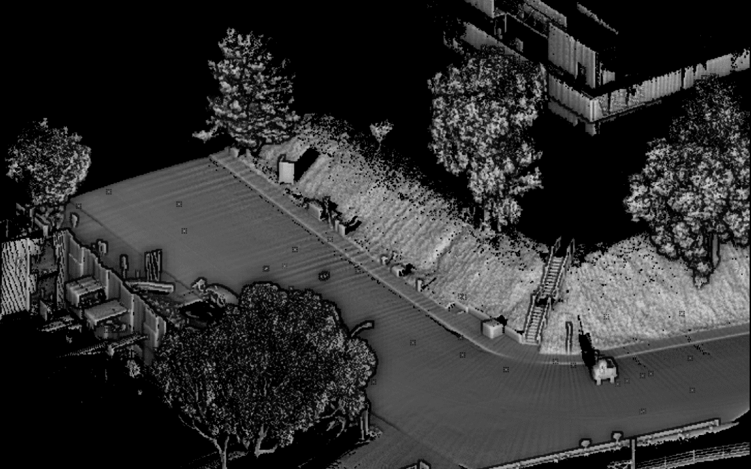
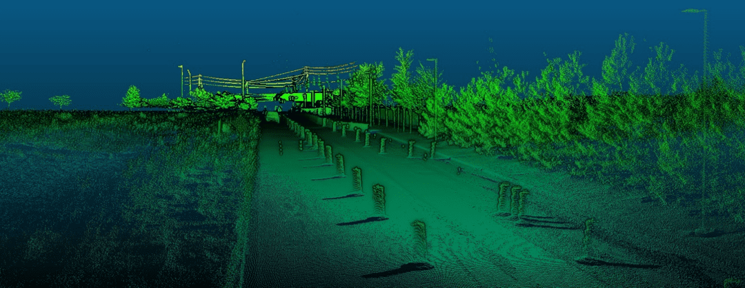
Road Surface Mapping with LiDAR – Part 2
Road Surveying using Geodetics’ Geo-MMS LiDAR Suite of Products The purpose of this blog – the second in a two-part series – is to continue to explain the capabilities of Geo-MMS LiDAR payloads for road surveys and highway scanning. We will explore the wider workflows...
Road Surface Mapping with LiDAR – Part 1
Leveraging your Geo-MMS for Detailed Road Surface & Infrastructure Modeling Following the economic downturn experienced in 2020, it is expected the US will significantly increase investment over the next number of years into the country’s infrastructure (e.g....
LiDAR Sensors, Simplified: Part 2 – LiDAR Systems Range and Architecture
LiDAR Systems: A Guide to Understanding LiDAR Sensors Function and Capability The purpose of this blog – the second in a two-part series- is to continue to explain the various metrics used when discussing Geo-MMS LiDAR sensor characteristics. Also, how to discern the...
LiDAR Sensors, Simplified: Part 1 – LiDAR System Point Density, Returns and Beam Divergence
A Guide to Understanding LiDAR Sensors Function & Capability The purpose of this blog (first in a two-part series) is to explain the various metrics used when discussing Geo-MMS LiDAR sensor characteristics and how to discern the oftentimes overwhelming...
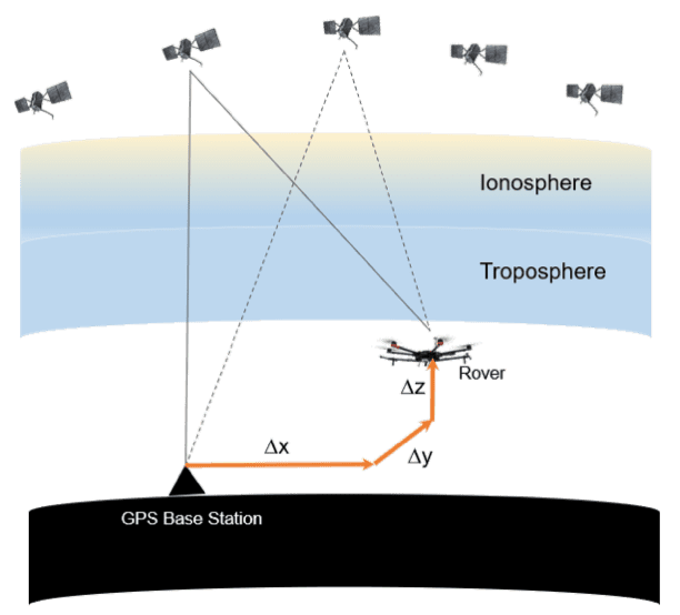
Optimizing Base Station Location for Mobile Mapping
A Quick Guide for your Mobile LiDAR or Photogrammetry Mission Base station placement for aerial or ground based mobile mapping projects is one of the most critical factors to consider for successful PPK-RTK processing. Given the number of variables involved in...
Geo-MMS Used for Railway Drone Inspection
Railway Drones: UAV-LiDAR Applications There has been a growing consensus globally regarding the importance of public transport, including a revival of rail for both public and freight transport after having long been neglected throughout much of the 20th century....
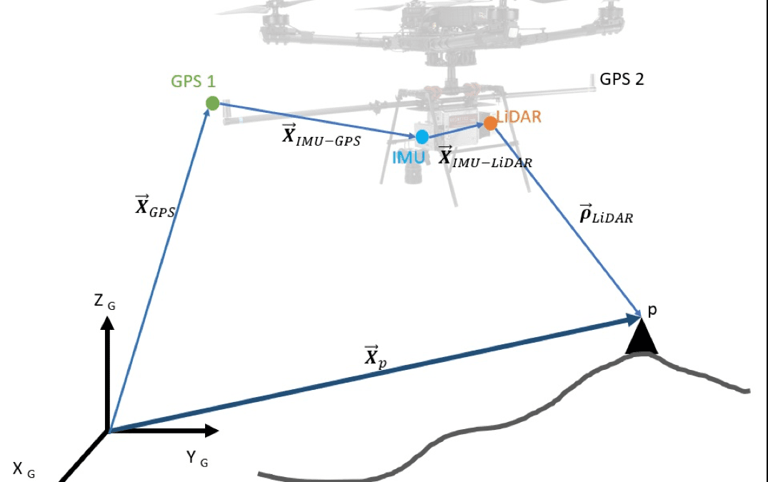
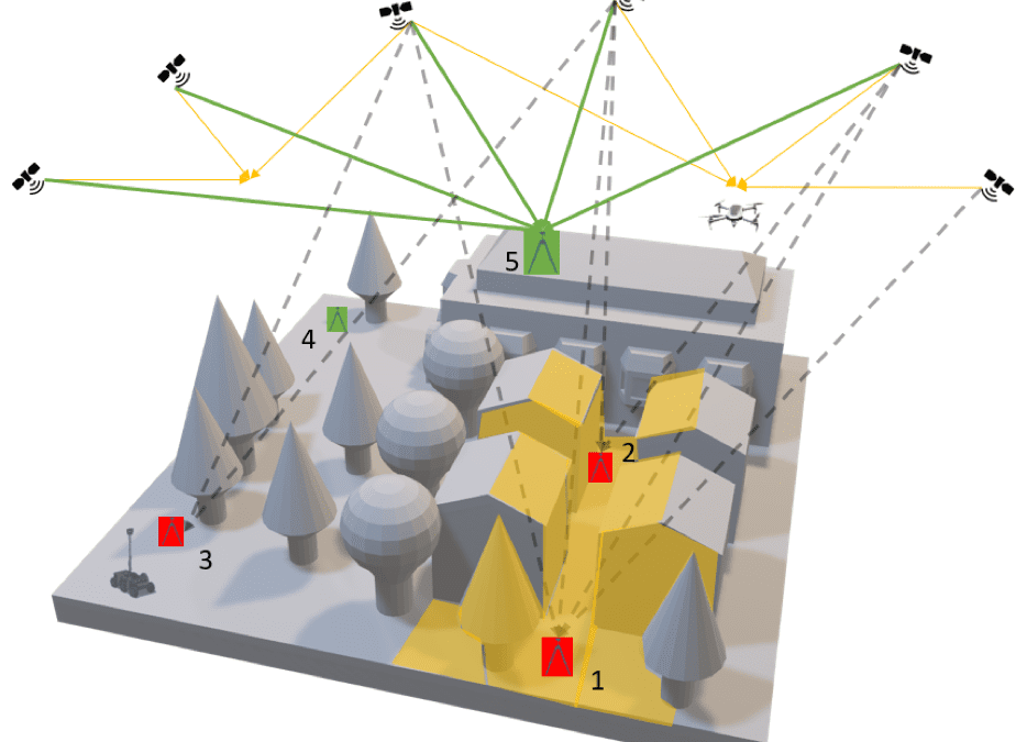
Principles of Georeferencing and UAVs
The Impact of Direct Georeferencing on Mobile Mapping Geodetics’ Geo-MMS product suite has applications in a wide variety of fields, including powerline inspection, Building Information Modeling (BIM) and precision agriculture. This article will provide some clarity...
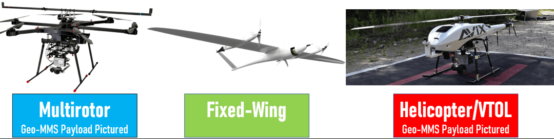
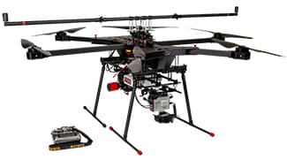
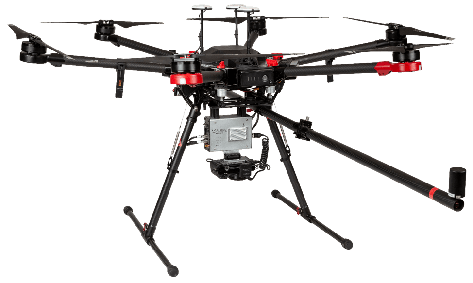
Determine UAV Payload Capacity for Geo-MMS
Geo-MMS UAV Payload Capacity Selection Guide The Geo-MMS suite of products can be mounted on a selection of Unmanned Aerial Vehicles (UAVs). For our concerns, UAVs with a payload capacity sufficient to support the Geo-MMS payload are categorized into three groups:...
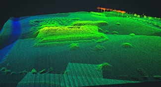
LiDAR Archaeology Discoveries
Leveraging Geodetics Geo-MMS LiDAR Archaeology Capabilities With the arrival of 2020 and the new decade, we find ourselves looking forward towards the future and the opportunities it holds. However, for some, these bright opportunities may lie deep in the past -...
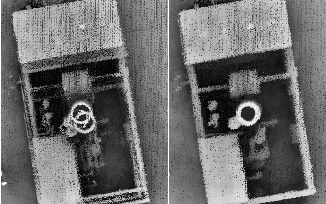
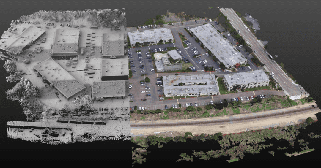
How LiDAR Point Cloud Data Can Affect Efficiencies
Classification Features LiDAR Point Cloud File The classification of features from the standardized file format for LiDAR point clouds (.las) is based on algorithms which analyze the LiDAR point-cloud data properties. The reflectance characteristics of each detected...
Dual-Camera Drone Configuration: Design by Application
Does a Dual-Camera Drone Offer Better Coverage? “Give the customer what they need, but not what they want”. This is true for dual-camera drone configurations on UAV-LiDAR and photogrammetry mapping systems. These can be found in such products as Geodetics’...

DEM, DSM & DTM: Digital Elevation Model – Why It’s Important
Digital Elevation Model vs Digital Surface Model vs Digital Terrain Model Geodetics’ Geo-MMS LiDAR and Point&Pixel products are used to generate highly accurate and dense LiDAR point clouds in the standardized LAS file format. With capabilities of up to four...
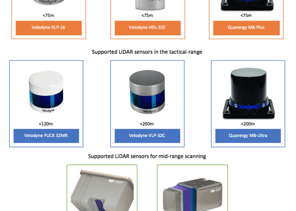
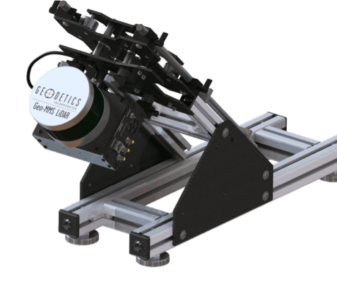
Selecting the Right LiDAR Sensors for Your Drone
LiDAR Sensors for UAV / Drone Application The Geo-MMS product suite is available with a wide range of LiDAR sensors. We classify LiDAR sensors into three categories: tactical, mid and long-range as illustrated below: When selecting the right LiDAR for your Geo-MMS...
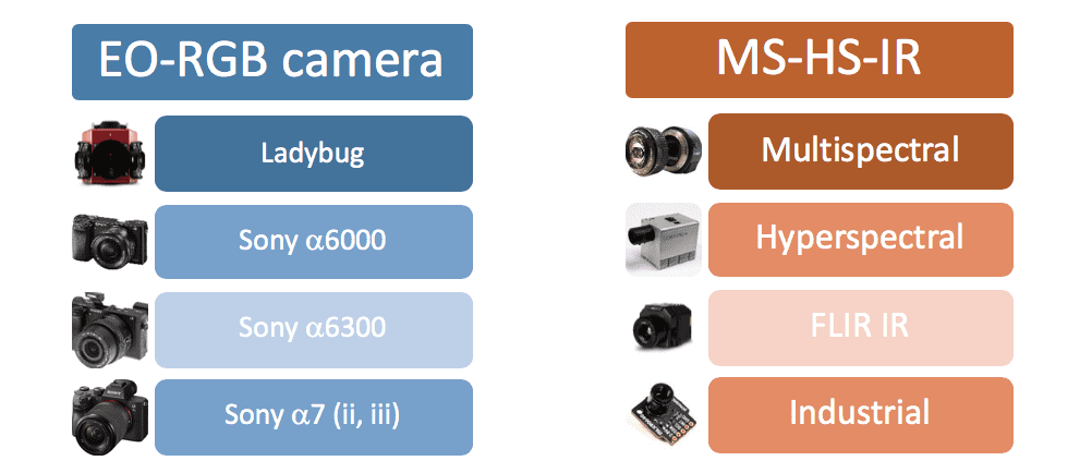
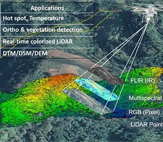
Choosing the Right Infrared or RGB Camera for Your LiDAR Drone
Learn What Infrared or RGB Camera Works Best with Geo-MMS Systems The Geo-MMS product suite can now be equipped with a wide range of infrared or RGB cameras, as shown in Figure 1 below. The RGB camera can be used as a solo sensor with the Geo-Photomap product. Others...
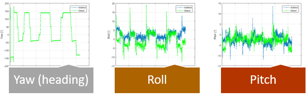
Why My Photogrammetry Software Doesn’t Support Image Attitude
And How Geodetics Geo-Photomap Photogrammetry Software Supports Image Attitude One of the main challenges in surveillance or photogrammetry systems mounted to multi-rotary UAV’s is the effect of vibration from wind, turbulence and pitching of the UAV. To address this...
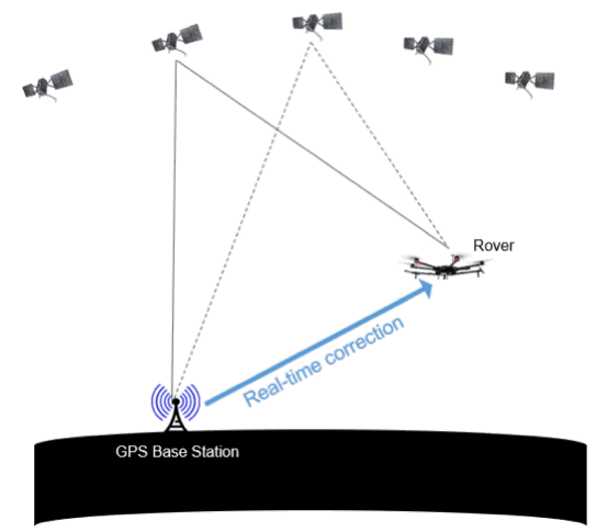
Do you Need RTK for your Geo-MMS UAV Mapping System?
PPK vs RTK Real-time Kinematic (RTK) and Post-processing Kinematic (PPK) are two related methods for improving GPS positioning accuracy – a technique commonly used in UAV mapping applications. Both methods make use of differential processing to enhance...
Does Geo-MMS UAV LiDAR Work in Snow Covered Areas?
Photogrammetry vs UAV LiDAR to Capture Snow Covered Areas Approximately, 40-50% of the land surface in the Northern Hemisphere is covered with snow during the winter session. From a regional scale, an accurate mapping of snow cover plays an important role in...
LiDAR Intensity: What is it and What are it’s applications?
Example Applications of LiDAR Intensity LiDAR intensity is recorded as the return strength of a laser beam. In the Geo-MMS LiDAR systems, it is a bi-product, provided as an integer number between 1-256. This number varies with the composition of the surface object...
How to Increase the Point Density of Your LiDAR System
LiDAR System Ideal for Aerial Mapping The primary reason that surveyors are switching from photogrammetry to LiDAR mapping systems is to obtain point clouds under trees, foliage and high canopies. This brings up the question: how can the point density of the point...
Fiber Optic Gyro: Do I need one for my Geo-MMS System?
High Grade IMU for Mobile Mapping Systems A question that we often get asked from our customers is: “Do I need a Fiber Optic Gyro (FOG) IMU for my Geo-MMS system?” The question can be restated as do we need a higher-grade IMU than MEMS-grade IMU’s for mobile mapping...
BIM Modeling and Geo-MMS: Smart Building Development
Combining BIM Modeling with Geo-MMS Products Another application of the Geo-MMS products is in Building Information Modeling (BIM). GeoBIM is emerging as a game changing strategy to solve contemporary multi-disciplinary challenges in our urban environments. This new...
Photogrammetry vs LiDAR – Which is Recommended for Quarry Mapping
Geo-MMS Offers Photogrammetry and LiDAR in One Payload The FAA Part 107 pilot license has opened the door to a wide range of new drone-based mapping applications that were previously prohibited by regulation. New UAV-mapping technologies are rapidly finding their way...
Post-Processing-Kinematic GPS for LiDAR Drone Systems
Post-Processing-Kinematic and GPS Baseline Separation Our Geo-MMS customers using our liDAR mapping drone system often ask, “how far our system can fly from the base station for post-processing-kinematic (PPK) data processing?”. The short answer is about 10 miles...
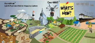
Geodetics Enhances Their Mobile LiDAR System Products
Geo-MMS 'Resolutions' for the New Year Welcome to 2019. All of us at Geodetics hope you had a great holiday season and a happy New Year. We are excited about our 2019 mobile liDAR system product roadmap and our New Years’ resolution to expand the scope of capabilities...
Exploring the Latest Drone Technology for Military UAV Defense Use
GPS-MMS UAV Defense The US military is expanding it's uav defense strategies, turning to logistical purposes by expanding their abilities to defend against their enemies. In recent years, drones have become an integral part to government agencies as they have managed...
Combining UAV Lidar and Photogrammetry
Geodetics Point&Pixel Geo-MMS LiDAR and Geo-Photomap utilize very different sensors and techniques for UAV mapping. Geo-MMS LiDAR directly geo-references LiDAR data to provide accurate and near real-time 3D point clouds. Geo-Photomap directly geo-references camera...
Enhancing UAV Photogrammetry Efficiencies
Geodetics Provides Images with Attitudes In the world of UAV Photogrammetry, the Aerotriangulation (AT) or the bundle adjustment is defined simultaneously refining the 3D model of captured images, estimating the camera position/attitude, and calibrating the camera. To...
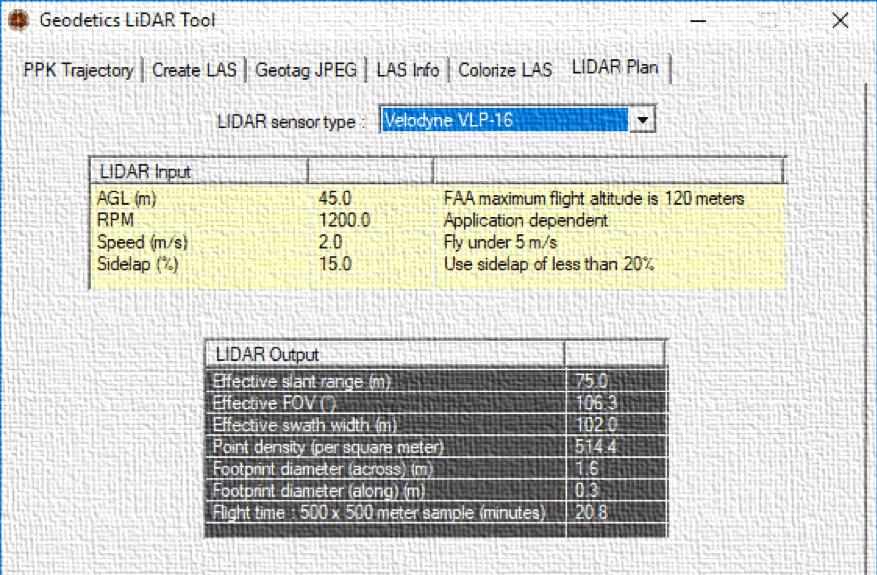
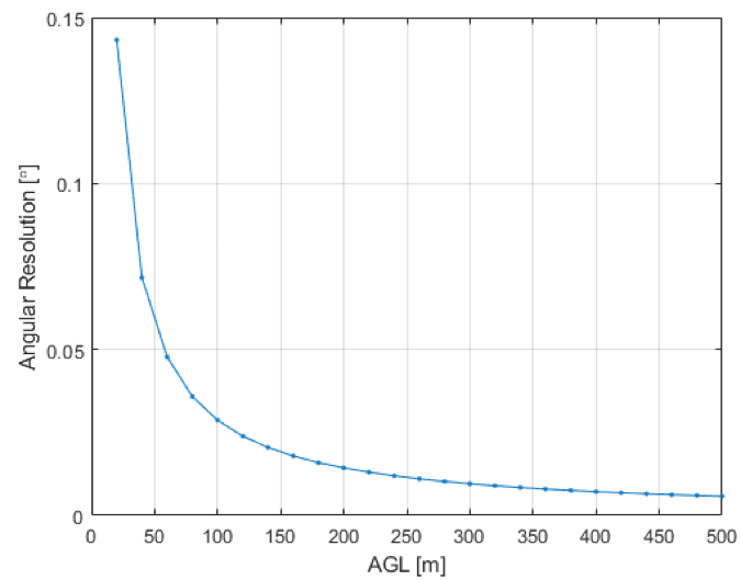
Drone Flight Planning: Geodetics Planning Software Update
Geo-MMS: From Flight Mission to Drone Flight Planning Three basic values must be known to correctly plan a data collection mission when using the Geo-MMS family of products: Appropriate flight altitude (AGL) Appropriate strip separation Appropriate flight speed These...
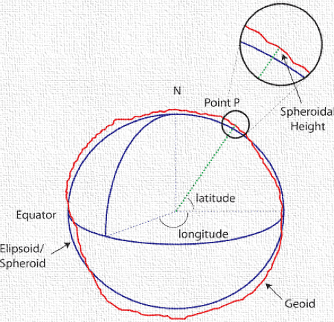
LiDAR Mapping Accuracy Explained Using Map Coordinates
Geodetics Supports Map Coordinates in LiDAR Mapping Accuracy In drone-based LiDAR mapping accuracy, the drone’s trajectory used in georeferencing the LiDAR mapping point cloud, is typically computed in the WGS84 coordinate datum. This can be further represented in...
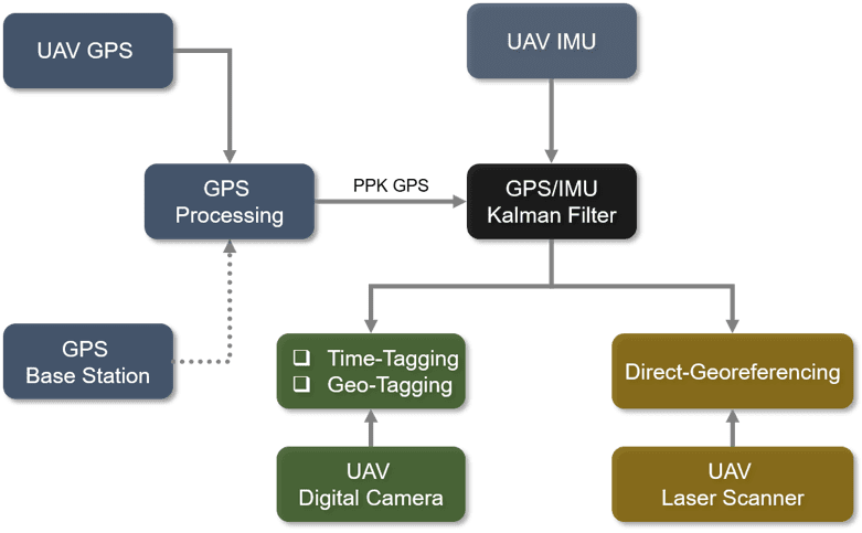
LiDAR for Drones: Leveraging Defense Grade Navigation Systems
Turn your GPS/IMU ‘Black Box’ into a ‘White Box’ One of the key-components of a UAV/Drone mobile mapping system is the use and integration of a GPS/IMU module. The purpose of this module is to provide detailed accuracy of the trajectory path including position and...

Drone Training and Geodetics Customer Service
LiDAR Drone Training and Customer Service Geodetics Geo-MMS family of products are in use all over the world. When purchasing a Geodetics mobile mapping system, first class customer service and top-notch drone training are available from Geodetics technical staff....
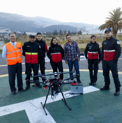
First Responders and Drone Usage in Emergency Situations
First Responders Quickly Adopt LiDAR Drones for Emergency Situations When it comes to emergency situations, first responders require agile real-time solutions which has led to first responders and drone usage increasing year over year. A real-time 3D map can provide a...
Geodetics Products for Advanced Precision Agriculture
Utilizing Geo-Photomap Multi-Spectral Sensors in Precision Agriculture Geodetics’ new drone for photogrammetry Geo-Photomap is a new technology offered in the Geo-MMS Drone LiDAR Mobile Mapping System product suite. Geo-PhotoMap tightly integrates GPS/IMU with RGB...
Using a LiDAR 3D Drone for Solar Farm Mapping
Geodetics' LiDAR 3D Drone for Design, Mapping, & Maintenance of Solar Farms Geodetics’ Geo-MMS LiDAR 3D Drone mobile mapping system, offers a quick and cost-effective tool for all phases of solar system deployment, from solar farm design, to solar farm mapping and...
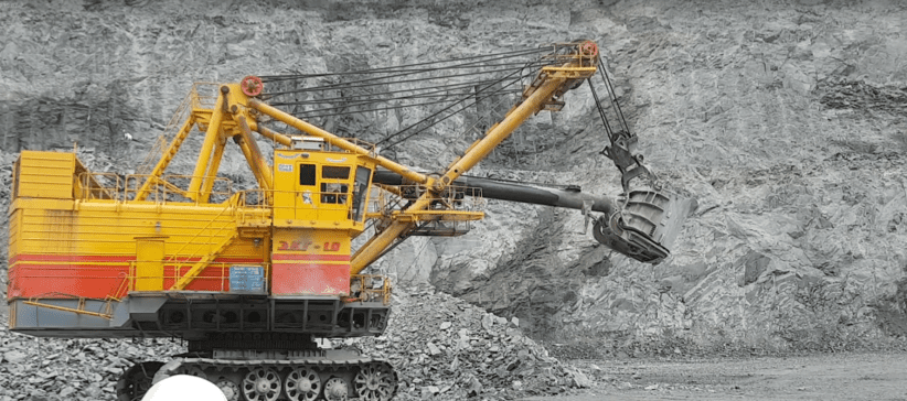
Quarry Mapping Using Geo-MMS LiDAR Drone
Quarry Mapping, Stockpile Surveying and Mine Management Using Mobile LiDAR Scanning Quarry mapping, stockpile surveying, volume extraction, and open-pit mine planning have typically been performed using ground-based survey sensors, an approach that is time-consuming...
Road Mapping Through LiDAR Sensor Technology
Leveraging Geodetics Geo-MMS 3D LiDAR Sensor The traditional management of roads and highway systems is expensive and time consuming for transportation agencies around the world given it involves a full crew equipped with expensive instruments, such as total stations...
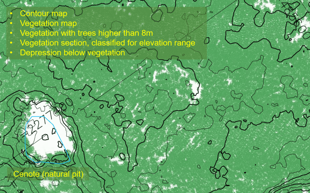
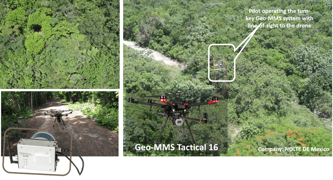
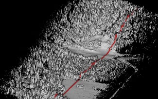
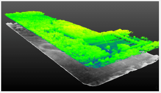
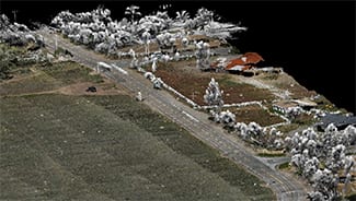
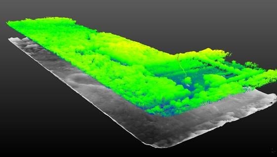
A Journey to Cancun, Mexico: Forest Inventory Using 3D LiDAR
Mapping Forests Using Unmanned Aerial Vehicles (UAV) Drones with 3D LiDAR Until now mapping impenetrable, overgrown forests was costly, time demanding and often ineffective. Drone 3D LiDAR technology has changed the way surveyors are able to capture images and data,...
Geodetics’ Now Offers 3 Mobile Mapping System Products
Bridging the Gap Between Drone Based (UAV) LiDAR Point Clouds and RGB cameras For several years, surveyors, environmentalists, archaeologists and similar industries have been saving time and money by leveraging the capabilities of Geodetics’ Geo-MMS LiDAR drone based...
