Railway Drones: UAV-LiDAR Applications
There has been a growing consensus globally regarding the importance of public transport, including a revival of rail for both public and freight transport after having long been neglected throughout much of the 20th century. When nations developed impressive rail networks, many of them became obsolete as the global population became increasingly dependent on automobiles. After a century or so, a realization of what was missed with rail transport has left many tracks in poor condition, often leading to unsafe conditions.
For their continued redevelopment, railway structural integrity must be assessed quantitatively. LiDAR provides an excellent option for such assessment, due to its high scan rate, point measurement density and speed of data processing. Railway drone inspection will be a wave of the future.
Besides tracking inspection and monitoring, the rail industry more generally is inclining towards the need for enterprise or system-wide data to be fed into integrated models, not dissimilar to the role of BIM in the AEC industries. This also feeds into planning for new lines and rail facilities. Planning through a virtual BIM or CAD platform allows for intuitive vectorization and increased engagement from stakeholders and the public – ‘Visualize before you realize’.
Rail Mounted Platforms
LiDAR mobile mapping units such as the Geo-MMS LiDAR Tactical 32 are frequently used on ground-vehicles for mapping and inspection of roads, bridges, powerlines, power poles, etc. The benefits of equipping LiDAR payloads on ground vehicles are well known. However, what may not be as widely known is that the same principles can be applied to rail infrastructure.

Figure 1 – Road-vehicle modified and equipped for mapping of rail tracks. Special thanks to SAIBrazil for sharing their experiences.
All Geodetics’ Geo-MMS LiDAR units can be seamlessly transitioned from a UAV to ground vehicle. This allows for road mapping, off-road mapping with ATVs and railway mapping on modified rail platforms. The systems can theoretically be integrated on a train locomotive; however, platform speed will heavily impact the LiDAR point density in the resulting point clouds. Scanning at a 10 m/s velocity will yield a point cloud half as dense as a scan moving at 5 m/s, all other things being equal. Depending on the FOV selected for the chosen LiDAR unit, the unit can also capture the surrounding ground topography and encroachment of features such as vegetation, shifted fences, utility poles, etc. This proves useful when performing work on rail lines tens or hundreds of kilometers long. This accounts for topographical undulations along the route and classification of encroaching features into their respective safety risks categories for further work. Identification is the first step towards mitigation.

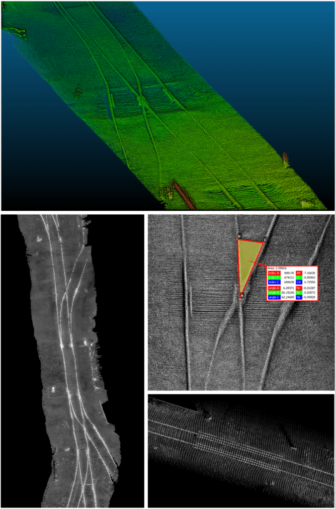
Figure 2 – LiDAR point cloud segments captured for railroad mapping using Geodetics’ Geo-MMS unit (SAIBrazil)
UAV Mounted Platforms
Rail-mounted platforms are useful for detailed point clouds extending long corridor distances. For more concentrated analysis of a singular section of rail, or for performing LiDAR scans on areas not exclusively targeting railway lines, UAVs are well accustomed due to their ease of use, rapid set up, and aerial maneuverability.
UAV platforms offer a non-intrusive method of data collection, avoiding interruption to train operations along the mapped route. UAV corridor mapping is equally as effective for rail networks as it is for any other corridor type (e.g. powerlines), perhaps even more so due to their more concentrated area of interest (AOI) and lower RPM necessary compared to the higher RPMs required for powerline work.
UAV-LiDAR systems also prove useful when mapping areas where no current rail infrastructure exists, but where future plans have been drafted. Rail route identification and integration into existing networks is multi-factorial, and the benefits LiDAR data provides are valuable for all stakeholders involved. Its benefits can be evaluated in terms of access to existing transport links, ground surface models to capture terrain undulations, and identification of existing obstacles. Railway drones can also be leveraged to optimize rail route efficiency and assist in environmental consultancy work required for the pre-planning stages. As with many applications of LiDAR, the benefit is not evident as a singular solution to the issue being addressed, but is realized as one of the many valuable tools needed to progress with such developments.
As the use of rail for public transport increases, LiDAR can quickly and accurately acquire data essential to developing safety standards and protocols. The curvature of rail lines determines at what speed a locomotive can travel at, and at what loading. Inaccuracies in these estimates – either through error of calculation or inaccuracy of data captured, is often responsible for carriage derailment that garners the headlines of our news on rare occasions. The capabilities of LiDAR offer a dual benefit in these circumstances. The accuracy of the data itself – its reliability and repeatability; and avoiding field visits by survey personnel to perform the measurements traditionally, limiting human involvement and risk.
LiDAR is quickly becoming a universal technology for the rail industry as it pertains to railway drone inspection and development. If you or your company are involved in the rail industry (project planning, project development, construction, operations, maintenance, safety, research or asset management), contact us today to find out more about how our growing suite of products can be an integral component of your projects.
