Leveraging Geodetics Geo-MMS LiDAR Archaeology Capabilities
With the arrival of 2020 and the new decade, we find ourselves looking forward towards the future and the opportunities it holds. However, for some, these bright opportunities may lie deep in the past – unravelling the stories of civilizations from centuries gone by.
UAV mapping systems such as Geodetics’ Geo-MMS are utilized by scientists and researchers all over the globe and are widely acknowledged as a practical and valuable tool for applications such as construction, environmental assessment and forestry management. One increasingly common application is archaeological exploration and research. The use of LiDAR archaeology is becoming resource for archaeologists around the globe.
The figure below shows a typical environment where this technique is utilized. Prior to the widespread availability of LiDAR mobile mapping systems such as Geo-MMS, areas with dense foliage cover such as the rainforest and jungle were often omitted from wide-scale archaeological projects. Photogrammetry techniques offer negligible value in these situations, as this passive remote sensing technique tells us nothing about the ground below the canopy – which is typically the focus of investigation for archaeologists.
With the arrival of cost-effective multi-return LiDAR scanners, extensive areas of forested areas could be mapped efficiently and extremely accurately, allowing for detailed Digital Elevation Models (DEM) and Digital Terrain Models (DTM) of the topography below the canopy (visit Geodetics’ previous blog on surface model reconstruction for more details). The application of LiDAR archaeology can be leveraged to see into jungles we have never seen into before and discover ancient ruins never seen by man due to the thick, overgrown nature of most of these terrains. The discovery possibilities are limitless.
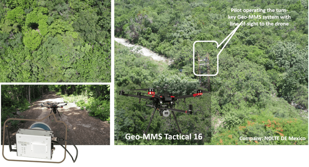
Figure 1. Special thanks to the NOLTE DE Mexico for sharing their adventures with us (Geodetics, Inc.).
Issues with data collection for projects in remote areas tend to lie with piloting the UAV sufficiently rather than the LiDAR scanner or software used for capturing or processing the data given the dangerous environments these projects entail. The figure above includes a photograph taken by a Geodetics customer carrying out a mapping mission in the Mexican forest. For the required line-of-sight capabilities between the pilot and UAV, a temporary scaffolding tower was erected at a clearing in the canopy to allow the pilot to operate sufficiently and for system performance to be maximized.
The use of LiDAR for archaeology has revolutionized the field. DEMs taken over extensive areas can reveal secrets of an area’s past by identifying walls, forts and other historical landmarks, impossible to identify through tree canopy and both difficult and time-consuming for individuals to identify on the ground. Inspection by individuals often hinders the ‘big-picture’ view of the area, with likely omittance of certain features which are part of a wider pattern.
Geodetics’ Geo-MMS capabilities have been proven with the dual-return sensors of the Geo-MMS Tactical LiDAR suite, up to the four-return scanning capabilities of the Geo-MMS LR (Long Range) LiDAR suite. The figure below shows the principle of multi-return LiDAR in action.

Figure 2. Elevation profile (left) taken from a section of a Geo-MMS acquired dataset along with the four return capabilities provided by Geodetics LR LiDAR products (right).
With multi-return LiDAR at the user’s disposal, creation of a DEM from the point cloud can be easily performed after accurate classification of the generated LAS point cloud file (see previous blog). From here, the details of ancient landmarks can be identified, visually augmented, analyzed and their properties researched further.
With the Geo-MMS LR option, this process can be conducted from UAV flight altitudes as high as 300m AGL. However, the LR option isn’t required for all work. Geodetics has customers that actively and regularly use our Geo-MMS Tactical systems for archaeological work. The performance range is critical, as sensors in the Geo-MMS Tactical 16 and 32 channels have an operation range up to 70m with dual-return capabilities.
For applications like archaeology, it is important to ‘visualize before you realize’. Before one can explore the ruins of an ancient city or identify a previously thought unoccupied area of human settlement, you need quality visualization and data analysis techniques, as provided by Geodetics. If you’re anticipating that moment of ‘realization’ with your archaeology project in 2020, contact Geodetics or Request a Quote today.

Figure 3. Geo-MMS Tactical LiDAR Sensor with dual-return capability used successfully for a LiDAR archaeology project being undertaken at Dartmouth University (study-relevant details purposely blurred).
