Digital Elevation Model vs Digital Surface Model vs Digital Terrain Model
Geodetics’ Geo-MMS LiDAR and Point&Pixel products are used to generate highly accurate and dense LiDAR point clouds in the standardized LAS file format. With capabilities of up to four returns per beam and a data rate up to 1000k (points/second) per return – depending on LiDAR sensor used. Each laser beam can penetrate through surface-terrain features such as vegetation, high canopy, etc., with the final return being reflected from the bare-Earth surface.
Digital Elevation Model (DEM), Digital Surface Model (DSM) and Digital Terrain Model (DTM) are three commonly implemented geospatial features generated with UAV mapping systems. Each data product delivers different elevation values as each model uses different methodologies. Elevation values from a LiDAR point cloud come from features including bare-ground, power lines, tree canopies or buildings. Selecting the right elevation model for your project can be challenging that is why Geodetics offers the following three simplified, but common interpretations for these data products:
– A DEM (Digital Elevation Model) Represents the bare-Earth surface, removing all natural and built features;
– A DSM (Digital Surface Model) captures both the natural and built/artificial features of the environment, as shown below;
– A DTM (Digital Terrain Model) typically augments a DEM, by including vector features of the natural terrain, such as rivers and ridges. A DTM may be interpolated to generate a DEM, but not vice versa.
For most LiDAR applications, focus is placed on the DEM and DSM as defined above, while DTMs are more applicable for GIS and cartographic representations and will not be discussed here.
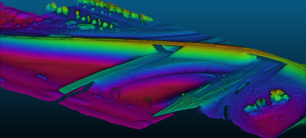
Geodetics’ acquired dataset of a road network. The DSM is represented by ground points, roads, vegetation and power lines in certain areas of this scene.
DEMs are of critical importance in areas such as land-use planning, infrastructural project management, soil science, hydrology and flow-direction studies. Across greater spatial scales, their use is key for the contouring of topographic and relief maps (as shown in the figures above and below).
Because DSMs represent the bare-Earth and all of its above-ground features, their use is widely applied in fields such as urban planning. For example, investigating how a proposed building would affect the views of residents and businesses, power line corridor inspections and aviation planning.
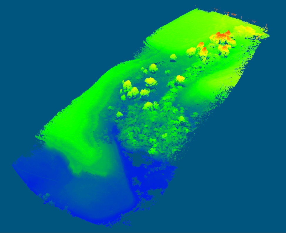
Geodetics’ acquired dataset of a park containing 2,993,079 LiDAR points.
In forestry management, a Canopy Height Model (CHM) is a separate model derived from elevation data in the point cloud. In forested areas, the difference between the DSM and the DEM can be viewed as CHM, representing the height of trees in the area above ground-level (see figure above). Software utilizing CHMs can also derive individual tree data, such as crown diameter, crown area and tree boundaries. This is of huge value to forestry management agencies and companies, allowing for substantial cost and time savings with UAV LiDAR monitoring, relative to manual inspection of individual trees.
Once accurate classification techniques have been applied to the LiDAR point cloud, clean ground points can be targeted and isolated from the remainder of the dataset. A DEM is created by generating a mesh from the LiDAR ground points using one of several interpolation algorithms to create a jointed fabric which accurately represents the real-world ground model. Generating a DEM from a LiDAR dataset alone can uncover hidden archaeological or geological features, which may have been masked from aerial view or photogrammetric analysis by naturally occurring terrain features (a new blog coming soon will discuss how our customers successfully use the Geo-MMS LiDAR for archeology).
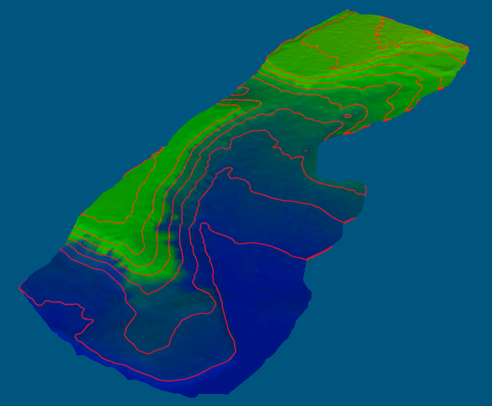
DEM generated from the ground points of dataset; 2-meter contour lines are fitted to DEM in this example.
Several point-cloud processing software packages offer DEM/DSM generation capabilities, allowing the user to create the surface model required for their project. The only prerequisite for this is a classified LAS point cloud file. The procedure is typically straight-forward and accurate, provided the LAS file has been accurately classified. After creating an elevation model, several editing, repairing and smoothing algorithms can be applied to remove inconsistencies, sharp edges and provide a more visually appealing result. The full process can be performed in a matter of hours. User input is minimal, only requiring some basic model parameters such as curvature weight, smoothing iteration etc. Once created, the model can be colored and various layers can be toggled on/off.
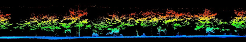
Geodetics’ acquired dataset of a road side-profile, demonstrating how a CHM can be derived from a DEM and DSM.
DEMS and DSMs are powerful and efficient tools for applications in a wide range of sectors. Geodetics’ advises our customers on the most appropriate modeling techniques for the elevation model best suited to their needs on a project-by-project basis. Geodetics’ also advises on LAS point cloud classification and provides an understanding of the parameters required for accurate DEM/DSM creation. For more information about these areas, please contact Geodetics.
