Geo-ECTO-1

Survey-Grade LiDAR + Imagery Capture Mobile Mapping Solution
The Geo-ECTO-1 mobile mapper is the industry-leading turnkey mobile mapping solution developed by AEVEX. Tailored to each client’s requirements and available in single and dual-LiDAR configurations, Geo-ECTO-1 is an invaluable technology for organizations tasked with assessment of critical transport infrastructure, including bridge and tunnel inspections, road/highway surveying and powerline mapping.
High-End Survey-Grade Mobile LiDAR Mapping
From infrastructure evaluation to environmental management, spatial data requirements and the mapping solutions that power them are evolving to cover a broader area more quickly, efficiently, and with greater accuracy. Mobile LiDAR mapping solutions from AEVEX provide powerful survey grade data that delivers a precise, accurate geospatial information in real or near real time. We know that individual mission and operational needs are varied and unique, so we offer customizable and agile applications that can be ground-mounted or drone based. With one in five miles of U.S. highways and major roads in poor condition and 45,000 bridges nationwide in disrepair, there is an increasing need for mapping and surveillance solutions that cover large areas safely, quickly, and accurately. The recently enacted bipartisan Infrastructure Investment and Jobs Act was put in place to facilitate a nationwide infrastructure rebuild and is expected to provide approximately 1.5 million jobs per year. This means that the federal government will be allocating money to the states for programs that include mobile LiDAR mapping functions
- Roadway mapping, planning, and infrastructure
- Construction operations
- Building and roadside structure mapping
- Roadside powerline assessment
- Bridge inspection-monitoring
- Urban planning
- Vegetation management
- Shoreline cliff erosion
Call For a Quote:
(858) 729-0872
Request More Info:
geodetics@aevex.com
Modular, Customizable & Adaptable
LiDAR mobile mapping is a highly accurate, powerful, and cost-effective way to evaluate infrastructure and other assets – but we know that it is not a one-size-fits-all solution.

- Versatile vehicle support (SUV, pickup, crossover, van), Rail mechanism for system forward/backward position adjustment
- Configurable for single or dual Teledyne Optech CL-360 (HD-XR) Adjustable pitch for dual-LiDAR scanners. Other LiDAR models available.
- Adjustable pitch/azimuth for dual-LiDAR scanners Side-facing and down-facing scan capability Adjustable Ladybug spherical camera mast height
- Dual-GNSS system for robustness and mapping accuracy.
- Easy installation and operation.
GEO-MMS NAVIGATOR – INS/IMU

SURVEY-GRADE LIDAR – SINGLE/DUAL
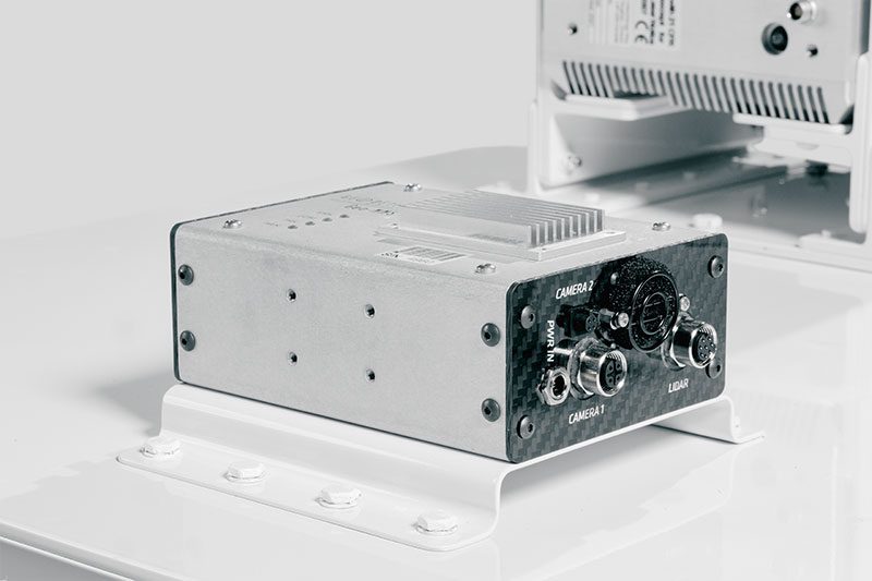
Ruggedized Control Box – Shock Mounted
User-Friendly & Efficient Operations
LiDAR allows for efficiency and safety while conducting mapping, surveying and research programs. Because daylight isn’t needed for operation, surveys can be conducted regardless of the time of day for higher productivity. It also increases safety by removing personnel from hazardous conditions such as tunnels, bridges, and power lines poles.
Geo-ECTO-1 Specifications Overview
Geo-MMS Navigator
Standard Configuration:
- Advanced MEMS IMU
- GPS receiver
- Dual GPS antennas
Options:
- Upgrade to military-grade SAASM receivers
LiDAR Sensor
Standard Configuration:
-
Teledyne Optech CL-360HD (UAV and mobile)
-
Teledyne Optech CL-360XR (long-range)
Options:
- Single or dual-LiDAR configuration
Imaging Sensor
Standard Configuration:
-
Teledyne FLIR Ladybug5+
-
Adjustable height
-
Interface unit for image triggering, time-tagging and geo-tagging
Control Box
Standard Configuration:
- Fully licenses PC with Geodetics’ software and sensor software for data acquisition
- Easy access to connect/disconnect all sensors
- Data storage on PC for live recording Ladybug5+ images and manual backup of Geo-MMS navigation data
- Control interface: Remote access over Wi-Fi
- Rugged build
Options:
- Upgrade PC with faster processer and discrete video card
- Keyboard, monitor, mouse
Power Unit
Standard Configuration:
-
Runs off vehicle power
-
Pure Sine Wave AC inverter
-
High-current 12V DC receptacle provided
Options:
-
Use existing inverter vehicle (minimum 800W – must be Pure Sine Wave AC inverter)
-
Car battery cable to control box
-
Cabling to system power
-
Remote control to turn inverter on/off
Roof Rack
Standard Configuration:
- Rail mechanism with quick release
Options:
- Customizable vehicle cross bars
Accessories
Standard Configuration:
-
All accessories necessary for field operations
-
Transport casing for all sensors included
Options:
- Laptop: BYOD (Windows 10 Pro or better) + Wi-Fi
