GEO-MMS: LiDAR & Photogrammetry Solutions
Powerful. Customizable. Cost-Effective.
Geo-MMS LiDAR
Geo-Photomap
Point&Pixel
What is Geo-MMS?
AEVEX’s Geo-MMS (Mobile Mapping System) is a cost-efficient, modular system for drone-based LiDAR and imagery capture solutions. Our three product categories and bundle options cater to a diversity of unique applications, use-cases and mission challenges. AEVEX’s extensive suite of ‘one-click’ advanced processing software provide a powerful, user-friendly toolbox for mobile and UAV-based mapping operations.
At the heart of Geo-MMS is AEVEX’s dual-antenna Inertial Navigation System (INS), with tight coupling of LiDAR, RGB, multispectral and other sensors. This Defense-grade proprietary navigation technology has been refined over AEVEX’s 20+ year history to a lightweight, platform agnostic system that can be deployed in minutes.

Geo-MMS Suite of Customizable Products
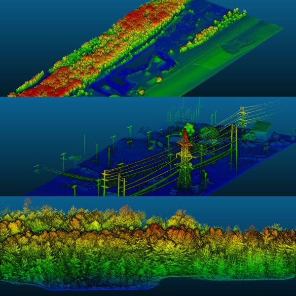
Geo-MMS LiDAR
Fully integrated LiDAR payloads for UAV and mobile mapping missions
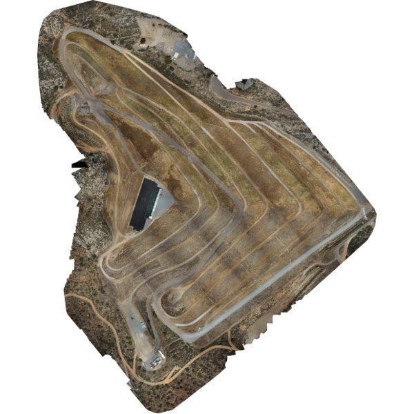
Geo-Photomap
GCP-free photogrammetry utilizing RGB and multispectral sensors
Point&Pixel
The best of Geo-MMS LiDAR and Geo-Photomap rolled into one for simultaneous data acquisition
The Geo-MMS Solutions Suite presents multiple options to cater to different applications and budgets. Each solution presents three levels: i) Tactical; ii) Operational; and iii) Strategic.
Foundation Solutions
Research Solutions
Utilities Solutions
Ground-Based Solutions
Geo-MMS Plus:
Advanced UAV Solutions
Why AEVEX?
- No annual software license fees
- GCP free Photogrammetry
- Dual-antenna interferometer on all systems – higher-accuracy, short calibration, more data in less time
- Support for RTK and PPK
- “One Click” PPK processing and LAS creation
- Support provided directly from system developers
- When you buy from AEVEX, you buy directly from the technology developer. If you buy from our competition, you buy from technology resellers
Integrated Flight Mission Planning

Flight mission planning software for Photogrammetry


Geo-MMS Success Stories
“When shopping for a lidar system to meet my business requirements, I needed to find the best system at the best price I could.
With AEVEX, I got that along with exceptional customer service and extremely knowledgeable staff. The system was affordable enough to get me into the lidar market without sacrificing quality of data. Now I am receiving contracts I did not expect to have because of it.”
“The AEVEX system with Velodyne lidar is simple and easy to use, but more important, it is a tough and reliable product. We have been scanning 8 hours a day over 7 months with no issues and no need of maintenance.”
“Having Velodyne lidar-based services has allowed Nolte de Mexico to provide accurate and cost-effective survey services on projects that otherwise were not possible! Using a AEVEX lidar UAV system, we successfully completed a 200-acre topographic survey in a highly vegetated, jungle parcel in Playa del Carmen, Mexico, for the design of a bus rapid transit project.”
