<div class="brochure"> <!-- [et_pb_line_break_holder] --><a href="https://geodetics.com/wp-content/uploads/2017/08/Geo-iNAV.pdf"><span>Download Datasheet</span> Including Technical Specs</a> <!-- [et_pb_line_break_holder] --><a href="/request-a-quote/"><span>Request A Quote</span></a> <!-- [et_pb_line_break_holder] --></div>
High-Performance, Rugged SAASM INS
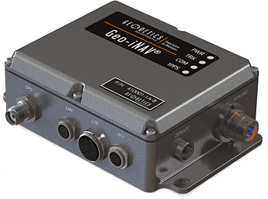
The Geo-iNAV® SAASM is a high-performance, rugged SAASM GPS-aided inertial navigation system. The Geo-iNAV SAASM tightly couples an RTK-enabled SAASM GPS sensor with a wide range of IMU’s including fiber-optic gyro and ring- laser gyro IMU’s for the highest levels of accuracy. The Geo-iNAV SAASM provides on-board data recording and hosting of user applications via the SDK. Geo-iNAV SAASM is designed to meet a wide range of Air, Land and Sea requirements.
- Simple integration
- RTK enabled SAASM GPS with path to M-Code
- Wide range of supported IMU’s
- Tight-coupling with Geodetics’ Extended Kalman Filter
- On-board data recording
- Post-processing support with RTD-Post
- In-motion dynamic alignment
- Wander Azimuth frame
- RS-232, RS422 and Ethernet (TCP/UDP) interfaces
- Includes GPS antenna and cables
- Size/ Weight/ Power – 33.8 in3 (4.73 x 3.95 x 1.81) / 20 oz., 10 – 30 VDC @ 2 Amps min. (not including external IMU).
- Temperature Range – Specified: -20°C to +65°C | Operating: -40°C to +70°C.
- Interfaces – External power connector, TNC GPS antenna connector, 1 Ethernet data port, 3 RS-232 serial ports, 1PPS output, 4 status LEDs, keyload connector, zeroize button.
- Real-Time Data Output – Navigation solutions at 100 Hz. available via Ethernet, RS-232, Solution Latency – 16 microseconds 1δ.
- Data Recording/Logging Navigation solutions – raw GPS & IMU data (for post-processing).
- Built-in support for many commonly used IMU’s – Honeywell HG19001, HG19301, HG17001, HG99001, Northrup Grumman LN2001, KVH 1725, 1750, 1775. Other IMU’s available upon request.
- Web User Interface – (status, configuration, log, SW update).
1 ITAR Restrictions Apply
- UAV, UGV, USV navigation and control
- Robotics & ROV control
- Antenna stabilization and pointing
- Mapping
- Intelligence, Surveillance and Reconnaissance (ISR)
