Photogrammetry vs UAV LiDAR to Capture Snow Covered Areas
Approximately, 40-50% of the land surface in the Northern Hemisphere is covered with snow during the winter session. From a regional scale, an accurate mapping of snow cover plays an important role in hydrology study, ecological, geochemical, and biogeochemical factors. Variation in snow cover extent can affect regional meteorological patterns. The other advantages of studying the snow cover is about estimation of the snowmelt, which is an important water resource and is used in the management of water usage, ground water storage, surrounding agriculture land, and activities due to its effect on river flow.
Measuring and Capturing
Measuring and capturing snow-covered areas using satellite-based remote sensing or radar remote sensing can be expensive for regional study. The classical land surveying mapping are tedious, time consuming and extremely difficult. Using photogrammetry will come up short as it cannot trigger fast enough in auto-focus thus causing the images to come out blurry due to white-balancing. Additionally, the captured images cannot be processed, as there are no features of interest available for the bundle adjustment process. Using Geodetics UAV Point&Pixel product, customers can use the LiDAR scanner for mapping snow covered areas. The snow-cover can be estimated by comparing the snow-free reference data, collected in a summer survey, with the data collected at the winter time, which allows for increased accuracy and efficiency
Example of Using UAV LiDAR
The sample below (thanks to Quebec University), was collected from a snow-covered area using the Point&Pixel system, equipped with the VLP-16 LiDAR sensor, and mounted on a DJI 600 Pro drone. The drone flew at 40m AGL, at a velocity of 2m/s. . A cross profile along the area, marked in the red-color, confirms that the LiDAR sensor can detect accurate point cloud data in snowy areas.
Image of Snow-Covered Area using the Point&Pixel System
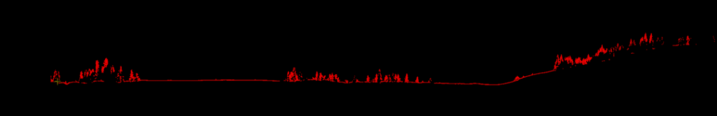
Red Marks Show the LiDAR Sensor Detected Accurate Point Cloud Data
Contact Geodetics to learn more about what Geodetics’ products can do – request more information today! Interested in obtaining a quote request one now.
