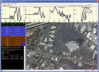
Real-Time Navigation Visualization Tool
Geodetics’ VYO Windows application provides a convenient interface to visualize time, position, attitude and related information (TSPI) streaming from a single or multiple Geodetics navigation systems. VYO can also be used to display recorded data.
The Geo-iNAV® and other Geodetics products can accept RTCM 3 as input. This is an industry standard protocol providing GPS reference data for differential GPS processing. Use of this reference data with Geodetics products can yield up to centimeter-level accuracy in real-time. VYO can be used to forward this RTCM 3 reference data to the Geo-iNAV® (s) from which it is receiving TSPI data.
