Turn your GPS/IMU ‘Black Box’ into a ‘White Box’
One of the key-components of a UAV/Drone mobile mapping system is the use and integration of a GPS/IMU module. The purpose of this module is to provide detailed accuracy of the trajectory path including position and attitude. This navigation information is leveraged to provide accurate time-tagging, geo-tagging and direct-georeferencing of both LiDAR for Drones and camera sensor data.
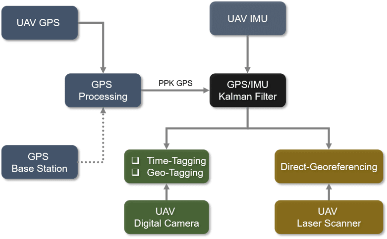
Figure above shows the general flow for this multi-sensor integration system.
Third Party “Black Box”
It is common for most UAV mobile mapping vendors to purchase and integrate third-party ‘black-box’ navigation systems to perform the complex mathematical operations necessary to operate LiDAR for drones and photogrammetry drones. These vendors act as system integrators rather than system developers thus their end-product is limited in performance capabilities provided by the third-party black-box.
In addition, these vendors lack the in-depth technical knowledge the third-party navigator possesses to respond to technical issues in a timely manner. They are heavily dependent on receiving answers directly from the developer of the black-box in order to provide assistance to their customers. This problem is amplified when it comes to fixing bugs, making system modifications and/or enhancing the system with advanced capabilities.
Geodetics “White Box”
Geodetics fully develops their UAV/Drone mobile mapping systems internally. Our Geo-MMS mobile mapping system includes our Geo-MMS navigator also known as a “white box”. Geodetics “white box” is designed and developed by Geodetics and leverages our expertise from years of delivering high-performance navigators for our defense customers. The navigator supports several different GPS receivers, different IMU grades, and includes our Extended Kalman filter software to integrate the sensor data. Using our flexible, extensible, and adaptive architecture, our solution provides many advantages to our customers, including:
- Providing customers with advanced technologies such as our Geo-Photomap and Point&Pixel products.
- In-depth knowledge of the complex processes developed by us and used in our systems
- Full support for the Post-Processing Kinematic (PPK) – ‘One-Click’ without annual license fees
- Support dual-antenna GPS configuration
- Trouble-shooting and bug-fixing support provided by the developers of the system
- Firmware upgrades available on our Web site
- Modification and customization
- Support for auxiliary aiding sensors, i.e., odometer, altimeter, etc.
- Support for tight-coupling with the vision sensors
- Flexibility in transition from dual-antenna data processing into single (in case, for some reasons, one of the antenna is not available)
- Support navigation solution in the challenging environments (low GPS observability)
Request more information to learn more about Geodetics Geo-MMS LiDAR for Drones and photogrammetry product suite – what makes our products superior to our competitors!
