Mapping Forests Using Unmanned Aerial Vehicles (UAV) Drones with 3D LiDAR
Until now mapping impenetrable, overgrown forests was costly, time demanding and often ineffective. Drone 3D LiDAR technology has changed the way surveyors are able to capture images and data, and through the use of a laser scan equipment on drones they are able to map in heavy vegetation and dense forestry for a fraction of the cost. By using lightweight 3D LiDAR payloads mounted on drones, surveyors and industries alike are able to penetrate the thickest of forests and effectively map out the terrain below the dense canopies. Drone 3D LiDAR systems are now accessible and affordable for most surveying businesses.
Recently Geodetics’ Geo-MMS LiDAR drone system, utilized by Nolte de Mexico on their recent trip to Planos, Cancun was used to map 500 hectares, covered with thick trees up to 8 meters high with severe cenotes in the area. The Geo-MMS LiDAR system was equipped with Velodyne HDL-32E Laser scanner and a FOG IMU. The flight altitude was set to 50m, with dual return LiDAR mode, and R1200 RPM.
By leveraging the Geodetics’ technology and equipment, Nolte de Mexico was able to generate a topography map for the entire area, taking advantage of the LiDAR mapping capability in thick foliage, where photogrammetry fails. The map shows the vegetation, elevation within the vegetation map, several cenotes as well as the depression below the vegetation – all features enhanced by this product.
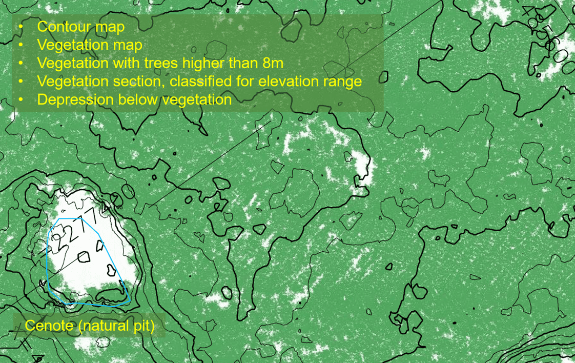
The vegetation mapping is generated utilizing the LiDARs’ returns to differentiate the terrain from the tree tops, as shown below.
As shown in this use case, Geodetics’ Geo-MMS LiDAR product is changing the way dense forests are mapped – enabling surveyors and/or historians to discover the treasures hidden below – as shown in the recent National Geographic documentary on the use of this technology in Guatemala in uncovering ancient Mayan ruins . The difference is by leveraging Geodetics Geo-MMS LiDAR product, one can accomplish the same or better outcome for a fraction of the cost.
Geodetics has a rich heritage in defense applications and is the leading provider for LiDAR Drone mobile mapping systems, Assured Positioning, Navigation and Timing (A-PNT) solutions and sensor fusion for mobile applications required for Air, Sea and Land including high speed pointing/attitude and relative position/angle applications. Geodetics’ has a laser focus on technologies necessary for maintaining precise PNT in the challenging environments of the future, which may not include access to GNSS satellite navigation. As a U.S. based company, we are proud to offer products that comply with Military SAASM GPS and M-Code requirements. All critical elements of Geodetics’ products, including algorithms, software, electrical and mechanical design are developed at Geodetics’ U.S. facility by our dedicated team of project managers, scientists, algorithm developers, software, hardware and test engineers.
Acknowledgment:
Special thanks to the NOLTE DE Mexico for sharing their adventures with us (Geodetics, Inc.).
